Gold in Louisa County, Virginia
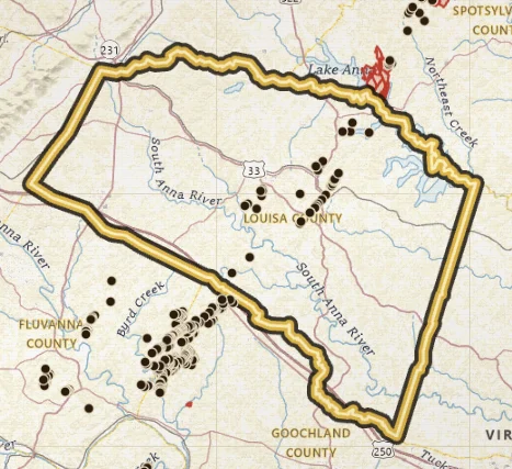
Louisa County is belt country: quartz-vein camps, a thick inventory of shafts and pits, and creeks that drain old mineralized ground toward the South Anna and North Anna.
Open Louisa County on the map · Create a free account to zoom closer: 3 days of full access
Water to study: South Anna and North Anna drainages, and the creeks that feed them.
Virginia Energy's gold inventory lists 37 mines and prospects in Louisa County. That is one of the denser stretches of the Gold-Pyrite Belt on the map. Named camps that keep showing up in the record include Tinder, Allah Cooper, Walton, Boxley, Jenkins, Josh, Luce, Slate Hill, and Walnut Grove.
Most of those pins are historic lode workings: shafts, open pits, and prospect pits in Piedmont rock. Placer research follows the water downhill from those sites, not a public beach on the county line.
Open the map on Louisa, turn streams on (they stay on), and compare named mines to the drainages. Then check land status. Louisa is mostly private ground.
Related reading: The Pyrite in the Name explains why pyrite shows up beside gold in quartz on Gold-Pyrite Belt ground.
Named mines in this county
-
Walton Mine
Walton is a named Louisa County lode camp on the Mineral quadrangle, with a confirmed Virginia Energy inventory pin (MRVID 171C-917) in a tight cluster with Cooper and other Mineral quad mines.
Names that show up in the inventory
These are documented site names, not verified pan spots.
- Tinder Mine
- Allah Cooper Mine
- Walton Mine
- Boxley's Mine
- Jenkins Mine
- Josh Gold Mine
- Luce Mine
- Slate Hill Mine
- Walnut Grove Mine
Neighboring gold counties
Common questions
Is there gold in Louisa County?
Yes. Louisa County is Gold-Pyrite Belt country. VaGoldMaps lists 37 documented gold mines and prospects here. Historic lode workings and creek drainages are the research story. Confirm land access before you pan.
Can you pan for gold in Louisa County?
Only where you have permission or a lawful public-land allowance. Most of Virginia is private. Parks and wildlife management areas are closed to collecting. Louisa County is a research area, not a county-wide pan permit.
Where should I start on the map?
Open Louisa County on VaGoldMaps, keep streams on, and compare historic mine pins to the drainages. South Anna and North Anna drainages, and the creeks that feed them. Then check land status and ownership before any field day.
All gold counties
- Spotsylvania
- Orange
- Buckingham
- Fluvanna
- Goochland
- Prince William
- Stafford
- Fairfax
- Halifax (Virgilina)
- Charlotte (Virgilina)
- Mecklenburg (Virgilina)
Gold in Virginia · Named historic mines
Open the map