Topo by Default: A Base Map Built for Creek Research
Most prospecting maps look fine at a glance.
Then you zoom in on a county you care about and realize you cannot quite read the creek, the ridge, or how the water drains off the hills.
That is the moment a topo map earns its keep.
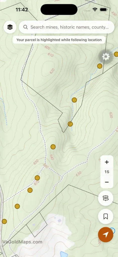
We recently changed the default view on VAGoldMaps so the Geologic Survey map opens on USGS Topo from The National Map - contours, relief, roads, and hydro already baked into the base layer.
We also made streams and rivers always visible. No toggle. Water lines stay on screen while you study mines, faults, lithology, and everything else.
This is not a treasure map.
It is a research setup - the kind of map I want open before I ever load the truck.
Why topo fits Virginia gold research
Virginia gold work is rarely flat-ground prospecting.
You are reading ridges, benches, tributaries, and how historic lode mines relate to modern drainage. Topo shows that relationship faster than a plain street or light-gray basemap.
The USGS Topo service combines National Map themes - boundaries, transportation, contours, hydrography, land cover, and shaded relief - into one reference view that scales from statewide context down to creek-level detail.
For Virginia Gold research along the gold-pyrite belt, that means you can:
- See elevation change and slope near historic mines
- Follow how a ridge drains into a branch creek
- Compare one watershed to another before you drive
- Stack research layers on a base that already speaks geology and terrain
Topo will not tell you where to dig.
It helps you ask better questions about where water and rock meet.
Streams are part of the base map now
When we first shipped the Streams overlay, you had to turn it on in the layer pills.
That made sense while we were testing the layer - but water is not optional context for Virginia gold research. It is core.
So streams and rivers from the USGS National Hydrography Dataset (NHD) now stay on by default. They do not count toward your free layer limit because they are part of the base experience.
If you want the longer story on why drainage matters for placer thinking, read Why We Added a Streams Layer. The workflow changed - the geology did not.
How to use it on the map
- Open the Geologic Survey map - it loads on topo with streams visible
- Pan into counties along the belt: Buckingham, Louisa, Spotsylvania, Goochland, and others
- Toggle research layers as needed: Historic mines, Faults, LiDAR hillshade, and more
- Switch basemaps when you want a different view: Streets, Satellite, or the 1849 Map for historic context
- Zoom in as far as your account tier allows - Prospector members get the deepest zoom for creek-scale study
At the highest zoom levels, topo tiles upscale slightly from the USGS cache so the map stays readable instead of going blank. You may notice a touch of softness at z17–18; that is normal when the tile service maxes out before the map does.
Pair topo with other layers
Topo plus always-on streams is the starting point. Stack what your research needs:
- Historic mines - Virginia Energy gold site locations on the same screen as drainage
- Faults - structural context for lode mineralization (see fault lines and intersections)
- LiDAR hillshade - bare-earth terrain when you want to strip visual noise (see what LiDAR can show you)
- USFS - National Forest boundaries when thinking about public-land access (always verify rules on the ground)
None of these layers replace boots, pans, or permission.
They shorten the distance between curiosity and a smarter plan.
Land access reminder
Seeing a creek or mine on a map does not mean you may prospect there.
Most land in Virginia is private. Streams cross farms, timberland, subdivisions, and posted property.
Always confirm ownership, respect posted land, and follow federal, state, and local rules before entering or working any waterway.
VAGoldMaps is for research and education - not land access or claim status.
Final thought
The best creek days start with reading the ground - elevation, drainage, and the old mine up the hill.
Topo puts that story on screen from the first click. Streams stay visible so water is never an afterthought.
Open the survey map at VAGoldMaps and see how the new default changes the way you read a familiar county.