Fault Lines, Intersections, and Why Structure Matters
Historic mines and creeks tell you where gold showed up.
Structure helps explain why those places line up.
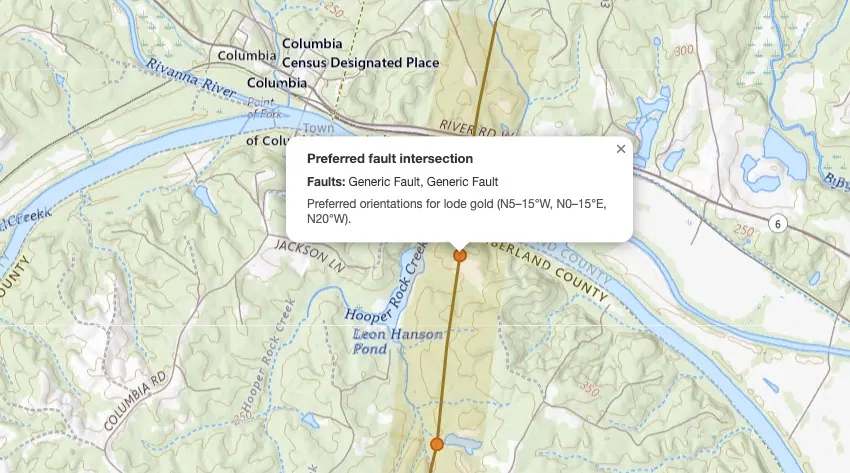
On VAGoldMaps, the Faults layer draws Virginia Energy fault traces across the Commonwealth. Turn on Preferred faults (Prospector / trial) and the map highlights orientations often associated with lode gold in the Gold-Pyrite Belt, plus intersection markers where those preferred trends cross.
This is not a treasure map.
It is a research filter: a way to ask better questions about the ground before you ever load the truck.
What the Faults layer shows
Fault data comes from the Virginia Energy DGMR geology map, the same public structural inventory used for geologic mapping research statewide.
When Faults is on, you see fault linework over the topo (or whatever basemap you chose). Click a segment and you get trend context for that trace.
Two modes matter:
- Faults - the full structural picture (available on free accounts; counts toward the free layer limit)
- Preferred faults - highlights traces in orientations frequently associated with lode gold mineralization, with gold-toned emphasis and intersection markers where preferred trends cross (Prospector members and active trials)
Preferred orientations highlighted on the map:
- N5-15°W
- N0-15°E
- N20°W
Those ranges come from geological studies of the Virginia Gold-Pyrite Belt. They are research cues, not guarantees that any given line hosts gold.
Why structure matters for Virginia gold research
Along the belt, mineralizing fluids moved through fractures and fault zones. Historic lode mines often cluster where structure, favorable rock, and time lined up.
For desk research, that means:
- A mine pin alone is a point
- A mine near a preferred fault trend is a point with context
- A mine near a preferred intersection is a place worth studying harder: more fracturing, more pathways, more reasons the rock may have been open to fluids
None of that replaces permission, boots, or a pan.
It shortens the list of places that deserve a closer look on the map.
For the broader belt story (counties, placer vs lode, creek reading), see Virginia Gold: Belt, Creeks & How to Research It.
How to use it on the map
- Open the Geologic Survey map. Topo and streams are on by default.
- Pan into belt counties you care about: Buckingham, Louisa, Spotsylvania, Goochland, Orange, Fluvanna, Cumberland, and neighbors.
- Turn on Faults in the layer pills.
- If you have Prospector or an active trial, turn on Preferred faults. Watch the in-view counts for preferred faults and preferred intersections as you pan.
- Keep Historic mines on and ask: do clusters sit near preferred trends or crossings?
- Click an intersection marker to see which preferred fault names meet there and the orientation note (N5-15°W, N0-15°E, N20°W).
- Stack streams (always visible) to think about lode-to-creek drainage. See Why We Added a Streams Layer.
- Add LiDAR hillshade when you want bare-earth terrain around the same structure. See What LiDAR Can Show You.
The Faults layer is for members, and an active trial includes it. Preferred faults and intersection markers unlock the same way.
A simple research loop
Use structure as a filter, not a treasure hunt:
- Start with a county or drainage you already have a reason to study.
- Note historic mines and how they sit relative to preferred faults.
- Mark intersections for a second pass, then compare to streams and LiDAR.
- Write down questions, not conclusions.
Example questions that stay honest:
- Do the known mines in this view follow a preferred trend?
- Where do preferred orientations cross near old workings?
- If those veins weathered for 150 years, which creek would material likely travel toward?
That loop is the point of the layer: sharper research, fewer random drives.
Where the data comes from
Fault linework is from Virginia Energy DGMR geology mapping (Faults layer), cached for use on VAGoldMaps.
Preferred orientation highlighting is an interpretation layer on top of that inventory, based on published associations for lode gold in the Gold-Pyrite Belt (N5-15°W, N0-15°E, N20°W). Intersection markers are computed where preferred traces cross in the map view.
The map mirrors public structural data for research and education. It is not a private claim list, access guide, or prediction of where gold will be found.
Land access reminder
Seeing a fault or intersection on a map does not mean you may enter, detect, dig, or prospect there.
Most land in Virginia is private. Always confirm ownership, respect posted property, and follow federal, state, and local rules before field work.
VAGoldMaps is for research and education, not land access, claim status, or digging advice.
Final thought
The best creek days still start at the desk.
Mines show where people worked. Streams show where water goes. Faults show how the rock broke, and preferred trends help you notice structure that may matter for lode systems.
Open the survey map at VAGoldMaps, turn on Faults as a member or during your trial (and Preferred faults if you have access), and see how structure changes the way you read a familiar county.