Why We Added a Streams Layer (and How to Use It)
A lot of prospecting research starts with a question that sounds simple:
Which creek am I actually looking at?
On a standard map, water can be easy to miss - especially the smaller branches that matter when you are trying to connect historic lode mines to modern drainage.
That is why we added a Streams layer to VAGoldMaps.
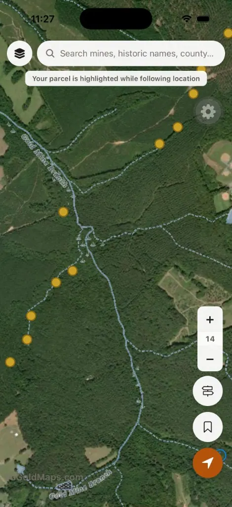
It overlays the U.S. Geological Survey National Hydrography Dataset so you can see rivers, creeks, and tributaries across Virginia while you study mines, faults, lithology, and everything else on the survey map.
This is not a treasure map.
It is a research layer - one more way to read the ground before your boots ever get wet.
What the Streams layer shows
Update (June 2026): Streams are always visible on the survey map now - no toggle. See Topo by Default for the full base-map change.
On the Geologic Survey map, blue hydro lines appear over the topo basemap.
That data comes from the USGS National Hydrography Dataset (NHD) - the nationwide stream network used in mapping and watershed work.
For Virginia gold research, the value is context:
- See which creek a historic mine drains toward
- Follow tributaries upstream and downstream
- Compare mine clusters to actual water lines, not guesswork
- Pair streams with Historic mines to think about lode-to-placer relationships
Virginia Gold often has a lode story and a creek story. The Streams layer helps you hold both on screen at once.
Why streams matter for placer thinking
Most hobby prospectors in the Commonwealth are working creeks, not underground shafts.
Over time, erosion breaks down quartz veins and carries heavy material downhill. Gold - being dense - tends to settle where water slows down.
That does not mean every creek holds gold.
But when you already have a geologic reason to study an area - the gold-pyrite belt, a historic mine record, favorable bedrock - drainage is the next logical question.
Common places worth studying in the field (once you have permission):
- Inside bends where current slows
- Bedrock cracks and exposed ledges in the channel
- Behind large rocks that create calm pockets
- Heavy gravel or black-sand layers
The Streams layer will not tell you which of those spots paid off.
It helps you see where the water goes so your field time is more intentional.
How to use it on the map
- Open the Geologic Survey map
- Streams are already on - blue hydro lines show rivers and creeks on the topo basemap
- Keep Historic mines on if you are studying lode-to-creek relationships
- Pan and zoom into counties you care about - Buckingham, Louisa, Spotsylvania, Goochland, and others along the belt
- Ask: If this mine weathered for 150 years, where would material likely travel?
Streams stay on at any zoom level and do not count toward your free layer limit.
For sharper creek detail, zoom in as far as your account tier allows - free accounts get more zoom than anonymous browsing.
Pair it with other layers
Streams is most useful stacked with research you are already doing:
- Historic mines - Virginia Energy gold site locations
- Faults - structural context for lode mineralization
- LiDAR hillshade - terrain and drainage shape before you visit
- USFS - National Forest boundaries when thinking about public-land access (always verify rules on the ground)
None of these layers replace boots, pans, or permission.
They shorten the distance between curiosity and a smarter plan.
Land access reminder
Seeing a creek on a map does not mean you may prospect there.
Most land in Virginia is private. Streams can cross farms, timberland, subdivisions, and posted property.
Always confirm ownership, respect posted land, and follow federal, state, and local rules before entering or working any waterway.
VAGoldMaps is for research and education - not land access or claim status.
Final thought
The best creek days usually start long before the first pan goes in the water.
They start with reading the map, studying the mines, and learning how the landscape drains.
The Streams layer is a small addition, but for Virginia gold research it fills an obvious gap: making water visible while you study the ground.
Open the survey map at VAGoldMaps and see how visible drainage changes the way you read a familiar county.