What LiDAR Can Show You Before You Ever Hit the Creek
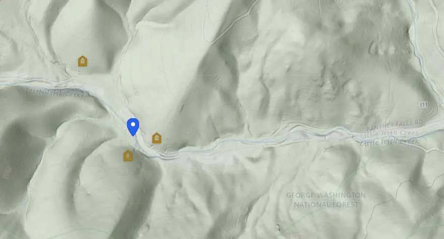
A lot of prospecting ground looks ordinary until you strip the trees off the picture.
That is what LiDAR hillshade does on VAGoldMaps.
The layer uses USGS 3DEP bare-earth relief so you can read ridges, benches, tributaries, and old surface disturbance without the canopy hiding the shape of the land. Zoom in first. Then turn it on. At a solid zoom the terrain starts talking.
This is not a treasure map.
It is a research view: the kind of map I want open before I decide a creek day is worth the drive.
What the LiDAR layer shows
LiDAR hillshade is a shaded-relief view built from elevation data. On the survey map it sits over your basemap so slopes, drainages, and subtle breaks stand out in ways satellite and street maps often blur.
Useful for Virginia gold research because you can:
- See how a ridge drains into a named creek
- Spot benches, cuts, and terrain transitions before you walk them
- Compare one stretch of ground to another without guessing from canopy color
- Stack historic mines, streams, and faults on the same bare-earth picture
It will not tell you where gold is.
It helps you ask better questions about where water and rock meet.
A Virginia example: Little Irish Creek
In the screenshot above, LiDAR is on over Little Irish Creek inside George Washington National Forest.
You can see the valley shape, the steep valley walls, side drainages feeding the main channel, and how the stream (always visible on the survey map) sits in that terrain. Contours still read. The canopy is out of the way.
That is the point of the layer: study a real drainage as landform first, then decide what else to stack.
National Forest ground has its own rules. See prospecting on U.S. Forest Service land before you treat any public parcel as open for casual work.
How to use it on the map
- Open the Geologic Survey map. Topo and streams are on by default.
- Pan to a creek or county you already care about.
- Zoom in until ridges and the channel read clearly. LiDAR is most useful at a solid zoom, not statewide.
- Turn on LiDAR hillshade in the layer pills (counts toward the free layer limit on free accounts).
- Keep streams visible and ask how the bare-earth valley matches the blue hydro line. See Why We Added a Streams Layer.
- Add Historic mines when you are studying lode-to-creek relationships. See Historic mine details.
- Add Faults / Preferred faults when you want structural context around the same ground. See Fault lines and intersections.
During a Prospector trial you can run every layer at once. Free accounts keep a lighter toolkit after the trial ends.
What to look for
Do not stare at LiDAR like a picture. Study it like ground you may walk:
- Changes in drainage shape and side channels
- Benches or flattened spots near active or older water movement
- Cuts, scars, or disturbed-looking ground
- Terrain breaks that topo alone softens
- Places where the bare-earth story differs from what satellite canopy suggested
Sometimes LiDAR does not give an answer. Sometimes it gives a reason to take a second look. That alone can save a wasted drive.
A simple research loop
- Start with an area that already has a reason to interest you.
- Zoom in, turn on LiDAR, and re-read the drainage.
- Stack streams, then mines or faults as needed.
- Write questions, not conclusions.
Honest questions sound like:
- Does this valley look the way I expected from topo alone?
- Where would heavy material settle if this ridge weathered into that creek?
- Is there a bench or break I should check on the ground (with permission)?
For the broader Virginia Gold story, see Virginia Gold: Belt, Creeks & How to Research It.
Where the data comes from
Hillshade on VAGoldMaps is derived from USGS 3DEP elevation products used for bare-earth terrain research. It is a public-data research layer, not a private claim list or access guide.
Land access reminder
Seeing a creek or ridge on LiDAR does not mean you may enter, detect, dig, or prospect there.
Most land in Virginia is private. National Forest and other public lands have their own rules and closures. Always confirm ownership, respect posted property, and follow federal, state, and local regulations before field work.
VAGoldMaps is for research and education, not land access, claim status, or digging advice.
Final thought
The best creek days still start at the desk.
LiDAR will not do the prospecting for you. It can tighten your plan, show the shape of a drainage like Little Irish Creek without the trees in the way, and help you spend daylight on ground that still makes sense after a hard look.
Open the survey map at VAGoldMaps, zoom into a familiar county, turn on LiDAR hillshade, and see what the bare earth changes about the story.