The Map, Rebuilt for Your Phone
About two-thirds of you open VaGoldMaps on a phone.
That number changed how I think about the map.
The old survey map was built for a desk: a page with a header, a footer, and a map in the middle. On a phone it felt like a desktop tool squeezed onto a small screen. You could still research. You just would not want to do it standing at a gate.
So we rebuilt it.
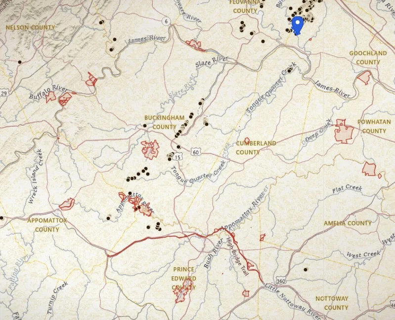
The new map is full screen. No site chrome in the way. Pinch zoom. Find me. Parks and WMAs you can tap. The places you already saved. USGS topo under your thumb, with drainages and historic workings on from the first load.
This is not a native iPhone app. It is the research map, in your phone’s browser, built for the way most of you already use it.
This is not a treasure map either. It is the same research-first VaGoldMaps: geology, history, and land context before anyone’s boots hit the creek.
Why a phone map is a different job
Desk research still matters. That is where you stack mines, faults, LiDAR, and a drainage until a county starts to make sense.
A lot of the next research does not happen at a desk. It happens in a truck on a Forest Service road. At a posted gate. On a bank, trying to remember which branch you meant. In a parking lot before you walk in.
That work needs a map that fills the glass. It needs pinch zoom that feels like a map, not a webpage. It needs a button that finds you. It needs a red park boundary you can tap for the name and the rule, not a layer you forgot to turn on.
The old map
A survey page with site chrome around it. Fine at a desk. On a phone, you spent more time fighting the layout than reading the creek.
The new map
Full viewport. Paper vignette, neatline, compass, statute-mile scale. Legend, Find me, and Places sit on the map. The ground is the page.
The previous map is still at /map for older links. New trips should start on the full-screen map.
What is on the screen when it opens
You should not have to assemble a research map from a pile of toggles before you can think.
On first load you get:
- USGS topo as the ground (switch to Streets or Satellite when you want them)
- Drainages from USGS hydro, so water is visible
- Tracts so parcel lines are there when you zoom in
- Old workings (historic gold sites from the Virginia inventory)
- Parks and WMAs on, with a plain note: prospecting is not allowed
That is the starting picture: terrain, water, history, and the closed ground, on one screen.
USFS, Faults, LiDAR, favorable rock, and earthquakes stay off until you ask for them. Heavy layers should be a choice, not a first-load tax on a phone radio.
How to use it in the field
A simple loop, the kind you can do with one hand:
1. Find me
Tap Find me when you want the map to come to you. It flies to your location, then clamps to the zoom your account allows. Hide me when you are done.
2. Pinch the creek
Pinch until ridges and the channel read. This is a map canvas, not a page zoom. If you hit your zoom cap, that is the account tier talking, not a broken pinch.
3. Tap the red line
Parks and WMAs are on. Tap a boundary for the name, acres, and the no-prospecting reminder. National Parks, state parks, and DWR wildlife areas are in that one toggle.
4. Open Places
The pins you already saved on the old map are here. Fly to one, edit it, share it, or save a tract / this view. Same places. New screen.
- Open the map on your phone.
- Pan to a county you already care about, or tap Find me if you are standing in it.
- Read topo and drainages first. Then tap an old working for the site record.
- If a red park or WMA boundary is in the way, tap it. Treat that line like a locked gate until the managing agency says otherwise.
- When a stretch of ground is worth coming back to, save the view or the tract under Places.
- Stack LiDAR, Faults, or favorable rock only after the base picture is clear. Those layers still matter. They just should not bury a phone on first open. See what LiDAR can show you and fault lines and intersections.
USFS is a separate toggle, off by default, Virginia only (George Washington and Jefferson). National Forest is not the same as a National Park. Read prospecting on U.S. Forest Service land and National Park boundaries before you treat any public line as an invitation.
Legend: what stays off until you need it
Open Legend for Ground and Layers. Checkboxes, not a lab.
- Ground: Topo, Streets, Satellite
- On by default: Drainages, Tracts, Old workings, Parks and WMAs
- Off until you turn them on: Faults, Earthquakes, USFS, LiDAR, Favorable rock
Faults and favorable rock are large. That is why they wait. On a phone, a 51 MB rock layer is a choice you make when you are ready to study rock, not something that should hitch the first pan.
Streams (drainages) stay in the picture because water is not optional context for Virginia gold research. The longer argument is in Why We Added a Streams Layer and Topo by Default.
Zoom, accounts, and honesty
The zoom rules did not change. The map just tells you them in the Legend:
- No account: zoom 10. Enough to see the belt and pick a county.
- Free account: zoom 12. Enough to plan a drive and read a drainage.
- Prospector / trial / Lifetime: zoom 18. Creek-scale, tracts, the detail you need when a parcel line actually matters.
Free accounts keep a lighter toolkit after a trial: fewer layers at once, one saved place. Members keep deep zoom, all layers, and more saved places. That is the same deal as before. The new map does not hide it.
If you want the short path from signup to useful map time, use Getting started.
Pair it with the notes you already have
This note is about the screen. The geology did not move.
- Virginia Gold: Belt, Creeks & How to Research It
- How Virginia’s gold sits in the rock
- Historic mine names and records
- LiDAR before you hit the creek
- National Park boundaries (closed)
Use the phone map to carry that reading into the field. Use the notes when you want the why.
Land access reminder
Seeing a creek, a mine tick, or a tract line on your phone does not mean you may enter, detect, dig, or prospect there.
Most land in Virginia is private. Parks, WMAs, and National Park Service units are closed to prospecting and mineral collecting. National Forest has its own rules. Always confirm ownership, respect posted property, and follow federal, state, and local regulations before field work.
VaGoldMaps is for research and education, not land access, claim status, or digging advice.
Final thought
The best creek days still start before the first pan goes in the water.
What changed is where that work can happen. You should be able to read a familiar county on the glass in your pocket: water, old workings, and the red line you are not supposed to cross.
If the old map bounced you on a phone, this is the one to try.
Open the full-screen map at VaGoldMaps, pinch into a creek you already know, and see whether the ground reads the way it should when the map is the whole screen.