New Layer: National Park Boundaries (Closed to Prospecting)
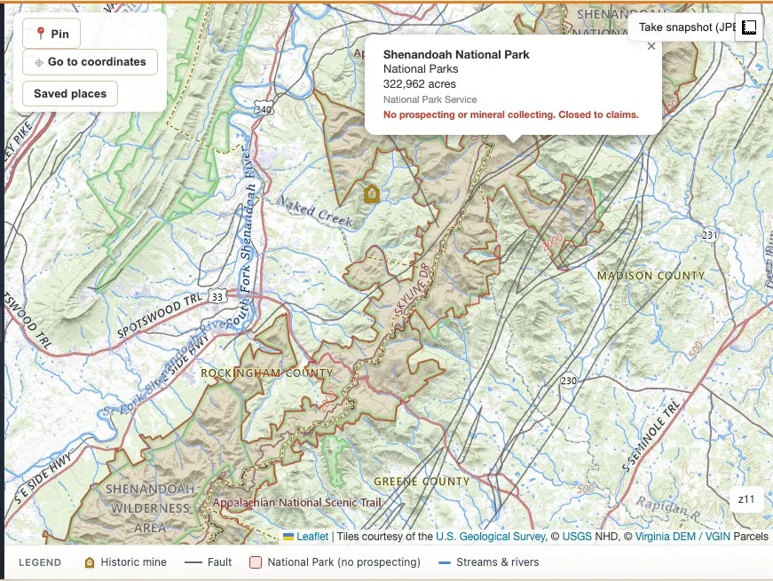
We added a new layer to VAGoldMaps: National Park Service (NPS) boundaries across Virginia.
Unlike our other research layers, this one is not a toggle. It is always on, drawn in red, and every unit pops up with the same line: no prospecting or mineral collecting.
That is on purpose. This layer exists to keep you out of trouble, not to invite more digging.
Why we added this layer
Our earlier note on prospecting in National Forests already flagged the short version: National Forest (USFS) land often allows casual gold panning, but National Park Service land generally does not.
Knowing that rule in the abstract is one thing. Knowing exactly where the line runs on the ground is another. Virginia's National Park Service units are not always obvious from a road map. Shenandoah National Park alone stretches roughly 105 miles along the Blue Ridge, and several smaller NPS units (battlefields, historic sites, monuments) sit right in the middle of counties that also hold historic gold ground.
So we pulled the authoritative NPS boundary data and put it directly on the research map, styled to stand out, so a quick glance tells you whether you are looking at open research ground or a closed federal boundary.
What the layer shows
The layer currently includes 15 National Park Service units that fall inside Virginia:
- Shenandoah National Park
- Colonial National Historical Park
- Appomattox Court House National Historical Park
- Cedar Creek and Belle Grove National Historical Park
- Richmond National Battlefield Park
- Petersburg National Battlefield
- Manassas National Battlefield Park
- Fredericksburg and Spotsylvania County Battlefields Memorial National Military Park
- Booker T. Washington National Monument
- George Washington Birthplace National Monument
- Fort Monroe National Monument
- Maggie L. Walker National Historic Site
- Arlington House, The Robert E. Lee Memorial
- Prince William Forest Park
- Wolf Trap National Park for the Performing Arts
Click any red boundary and the popup shows the unit name, type, approximate acreage, and a plain warning: no prospecting or mineral collecting, closed to claims.
Boundaries come from the NPS Land Resources Division's authoritative tract and boundary dataset, the same source NPS itself uses for land status mapping.
Why National Parks are closed to prospecting
National Park Service regulations protect natural features, including rocks and minerals, as part of the park resource itself.
Under federal rule, it is generally prohibited to possess, destroy, disturb, or remove mineral resources, including gold, from land within National Park System boundaries. That covers casual panning and metal detecting, not just commercial mining. There is no small-scale or hobbyist exception like there can be on multiple-use USFS land.
Source: National Park Service - Mineral Resources Protection
This is a real, enforceable boundary, not a suggestion. Treat the red line on the map the same way you would treat a locked gate.
How to use this on the map
- Open the Geologic Survey map. The National Park layer loads automatically, no toggle needed.
- Pan along the Blue Ridge to see the full Shenandoah National Park boundary, or zoom into a county to check for smaller NPS units nearby.
- Click any red boundary for the unit name, type, and acreage.
- Cross-check against Historic mines, Faults, and USFS boundaries before you plan a field day. Historic gold ground and federal boundaries do not always respect each other.
- When in doubt near a boundary line, treat it as closed and confirm with the relevant agency before you go.
Land access reminder
This layer tells you where prospecting is closed. It does not tell you where prospecting is allowed.
Most land in Virginia is private, and public land carries its own rules depending on the managing agency (NPS, USFS, state, or local). Always confirm current regulations with the agency that manages the land, and never assume permission from a map alone.
VAGoldMaps is for research and education, not a legal determination of land status or access rights.
Final thought
A good research map should make it easier to plan a legal, low-impact day at the creek, and that includes knowing where not to go.
Open the survey map at VAGoldMaps and see how the new red boundaries change the way you read a familiar county.