How Virginia's Gold Actually Sits in the Rock
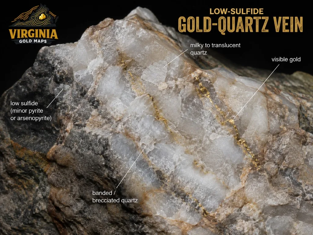
Most Virginia gold research starts with a pin, a creek, or a county name.
The next useful question is quieter:
How does the gold actually sit in the rock?
That answer shapes what historic mines look like on LiDAR, why shallow pits came first, and why drainages below old workings still matter for placer thinking.
This note paraphrases public findings from Palmer Sweet's Virginia gold summaries and the 2023 National Academies report The Potential Impacts of Gold Mining in Virginia. It is research context for the map, not mining advice.
Two districts, one Piedmont story
More than 95 percent of known historic gold mines and prospects in Virginia sit in the Piedmont. Two districts dominate the inventory:
- Gold-Pyrite Belt - the main NE-SW band through north-central Virginia, roughly 175 miles from just south of Washington, D.C., into the central Piedmont
- Virgilina district - the second major cluster, in south-central Virginia (Halifax, Charlotte, and Mecklenburg Counties)
A few smaller Blue Ridge occurrences exist too (including Floyd County placers worked as late as the 1980s), but the map density that draws researchers is Piedmont ground.
For belt counties, creek reading, and research workflow, start with Virginia Gold: Belt, Creeks & How to Research It.
Lens-shaped veins that dip steeply
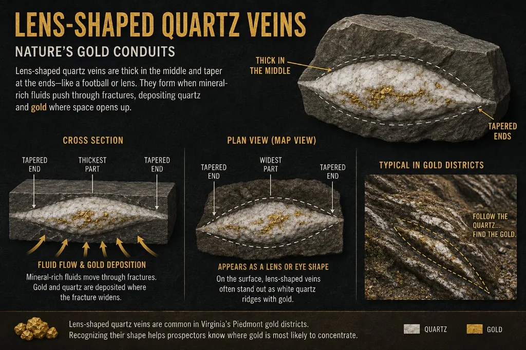
Virginia's principal gold deposits are low-sulfide, gold-quartz vein systems. In plain language:
- Gold sits in quartz veins (often with a little pyrite and related sulfides)
- Veins are commonly lens-shaped: thick in places, pinched elsewhere, sometimes only inches wide and elsewhere measured in many yards
- They often dip steeply, so early miners chased them with shallow pits and trenches, then shafts and underground workings
Total pyrite in many of these ores averages around 1 percent and rarely exceeds about 4-5 percent. That is "low sulfide" compared with massive sulfide bodies that can sit nearby in the same belt.
That geometry is why a historic "mine" on the map is often a cluster of disturbed ground, not one tidy hole. Pinch-and-swell veins reward patience underground and leave messy surface footprints when the shallow free-milling ore is gone.
Near-surface free gold vs gold locked in pyrite
Weathering matters.
Near the surface, oxidized ore often held free gold that was easier to mine and process. Historic camps started with open pits and trenches in that zone.
Deeper, unoxidized ore commonly holds gold bound up with pyrite and other minerals. That meant underground work, harder processing, and higher cost. Many Virginia operations never stayed profitable once the easy oxidized zone played out.
For map research, that history still shows up:
- Shallow pits, trenches, and dumps near named mines
- LiDAR textures that look "worked" long after the timber and stamps are gone
- Creek systems downhill from those veins, where erosion can move liberated gold into placer settings
See What LiDAR can show you and reading Virginia creeks.
Gold-quartz veins and nearby massive sulfides
In the Gold-Pyrite Belt, low-sulfide gold-quartz veins often sit to the west of more sulfide-rich massive sulfide deposits. They can be close enough that commercial mining of one risks disturbing the other.
Hobby research does not need engineering detail. The useful takeaway is simpler: not every "gold" neighborhood is the same rock chemistry. When you read historic names, some camps chased free gold in quartz. Others sat near heavier sulfide ground that behaves differently when water and air get involved.
Structure still helps explain why veins line up. Pair this geology note with fault lines and intersections.
How Virgilina differs
Virgilina is the second major historic district, not a footnote. Copper and gold both show up there, hosted in low-sulfide quartz veins, but the district's rock story and metal pairing differ from the classic Gold-Pyrite Belt pattern.
One of the better-known historic gold names is the Red Bank Mine, worked in the early 1900s on a gold-bearing quartz vein that ranged from a few inches to several feet wide.
If your research only pans Spotsylvania, Louisa, and Buckingham, you are missing half the Piedmont inventory story. Zoom the map south into Halifax, Charlotte, and Mecklenburg and compare mine density to the central belt.
Scale and history that keep the pins honest
A few numbers help set expectations:
- Roughly 100,000 ounces of gold produced in Virginia from the early 1800s through 1947
- Peak years clustered from the mid-1830s through the mid-1850s, before California drained capital and labor west
- Earliest written gold reference often cited: Thomas Jefferson's 1782 note of a gold-bearing rock along the Rappahannock near Fredericksburg (full story)
- First well-known lode locality: Whitehall Mine in Spotsylvania County (1806)
- Last commercial gold production commonly dated to 1947 (by-product recovery in Spotsylvania County), with only intermittent exploration and small placer attempts since
Park's older gold-pyrite belt summary for 1829-1934 puts belt production on the order of about 91,000 ounces total, with a single-year high near 6,300 ounces in 1849. Compare that with modern western mines that can produce more in one year than Virginia's entire historic belt run. Virginia's story is deep history and dense research ground, not Nevada-scale tonnage.
Named heavyweights still worth studying by page: Whitehall, Booker, Vaucluse, Goodwin, and Tellurium.
How to use this on VaGoldMaps
- Open the Geologic Survey map (topo and streams are on by default).
- Keep Historic mines on and pan the Gold-Pyrite Belt, then jump south to Virgilina counties for contrast.
- Ask whether a pin looks like shallow surface work, deeper shaft country, or a sparse prospect.
- Turn on LiDAR hillshade around named mines and look for pits, cuts, and uneven ground.
- Trace streams downhill from mineralized ground for placer research questions.
- Add Faults / Preferred faults when you want a structural "why here" layer.
None of that is a dig invitation. It is a way to read rock history before you plan a field day.
Land, mercury, and honesty
About 84 percent of Virginia land is privately owned. Gold research on the map almost always ends at a permission question on the ground.
Historic Virginia mills also used mercury amalgamation in the 1800s and early 1900s. That practice is long gone from U.S. commercial gold mining, but legacy mercury can still exist in soils, dumps, and sediments at old sites. Treat abandoned workings as hazards and contaminated ground, not free ore piles.
VaGoldMaps is for research and education. Confirm ownership, follow the rules, and leave unsafe ground alone.
Further reading
- National Academies of Sciences, Engineering, and Medicine (2023), The Potential Impacts of Gold Mining in Virginia (free PDF)
- Sweet, P.C. (1971, 1980, and related Virginia Minerals / VDMR summaries on gold mines and prospects)
- On this site: Virginia Gold guide, historic mine details, structure
Final thought
Creek gold and mine pins make more sense when you know the vein story behind them.
Lens-shaped quartz. Steep dips. Free gold near the surface. Pyrite at depth. Two Piedmont districts with different flavors of the same broad theme.
Open the survey map at VaGoldMaps, pick a named mine you already know, and look at it again with the rock story in mind.