Spotsylvania County · Brokenburg
Whitehall Mine
Whitehall is the name Virginia historians tie to the first documented lode gold find (1806), with Mint-recorded production through the mid-1800s on the Brokenburg quad between Norton Prong and Whitehall Creek.
Open on map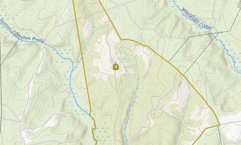
- Known for
- Believed first Virginia gold locality (1806)
- Reported output
- $1,800,000 from 1848 to 1881 (Philadelphia Mint records; Sweet 1971)
- County / quad
- Spotsylvania County · Brokenburg
- Site type
- Shaft (historic workings); also worked as placer nearby
- Inventory
- MRVID 170B-101 · MRDS W000452 (White Hall / Stockton & Heiss)
- Acres (AML)
- About 30 acres on file
Whitehall is not just another pin on the Virginia gold map. It is the name historians keep coming back to when they ask where the Commonwealth's gold story really starts.
Palmer Sweet put it plainly in Virginia Minerals (1971): a gold mine, believed to be the first locality in Virginia in which gold was found (1806), with $1,800,000 from 1848 to 1881 according to records of the Philadelphia Mint.
That single sentence is why Whitehall still matters for research. First discovery, then decades of recorded production in the heart of the Gold-Pyrite Belt.
Where it sits
Virginia Energy's inventory lists the site as White Hall (Stockton & Heiss) on the Brokenburg 7.5′ quadrangle in western Spotsylvania County (MRVID 170B-101, MRDS W000452). Older descriptions place it about 1.5 miles northwest of Shady Grove Church, in the same mineralized belt that later filled with mines toward Wilderness Run, Lake Anna, and Orange County.
On abandoned-mine records the footprint is substantial (about 30 acres). The catalogued site type is a shaft, but period writers also describe surface cuts and nearby placer washing. In other words: this was a camp, not a single hole in the ground.
First gold in Virginia (1806)
Gold in place at Whitehall is usually dated to 1806. Virginia Energy still cites Whitehall as the location of the state's first lode deposit (with first production often rounded to around 1804 in overview tables). Either way, the point for prospectors is the same: Virginia's documented hard-rock gold story begins here, generations before California.
An earlier written reference often cited in statewide summaries is Thomas Jefferson's 1782 note of a gold-bearing rock along the Rappahannock near Fredericksburg. See Jefferson's Rappahannock Gold for the specimen (4 pounds of ore, not a 7-pound nugget). That story is not the same as a developed lode mine. Whitehall is the name that marks the start of documented hard-rock work.
Early work was shallow. Free gold in quartz near the surface, open pits and trenches, the kind of ground that shows up as disturbed topography long after the stamps are gone. That pattern matches the broader Piedmont story: oxidized near-surface ore first, deeper pyrite-bearing ore later. See how Virginia gold sits in the rock.
Later writers recycled vivid nineteenth-century anecdotes: rich pockets reported in small surface areas, and placer nuggets washed nearby before Credner's Civil War-era visit. Treat those dollar figures as historical color. Sweet's Mint summary is the cleaner production benchmark for the main working period.
The big working years: 1848 to the 1880s
The mine's best-documented run is mid-century. USGS and Diggings-style summaries commonly say Whitehall was worked from about 1848 to 1884, with Civil War interruption. Shafts went deeper as shallow ore played out. Reports mention underground work on the order of ~100 feet, surface and underground together, gold with quartz gangue (and other sulfides noted in some compilations).
Sweet's 1971 note is the production line that sticks: about $1.8 million attributed to 1848-1881 via Philadelphia Mint records. That is period dollar value, not a modern ounce conversion you should paste into a spreadsheet without care. For map research it is enough to know Whitehall was not a footnote producer. It was one of the belt's serious names while Virginia gold still competed for eastern capital.
After the 1880s, western rushes and thinner shallow ore left most Virginia camps quiet. Whitehall closed with the rest of that generation of Piedmont mines. Remnants reported in later site notes include caved pits, cuts, and dump material. The land today is research ground, not a public dig site.
What LiDAR shows near the pin
Topo tells you the labeled creeks and the contour story. LiDAR strips the canopy and shows the ground itself: ridges, benches, and the rough texture that often marks old surface work.
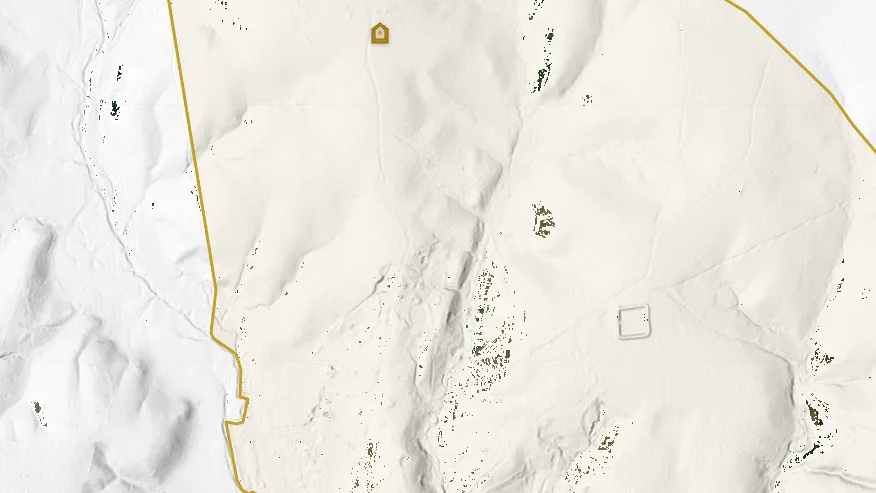
Zoom in on the Whitehall pin with LiDAR on and compare the disturbed ground to the smoother hillsides nearby. Pair that with streams: any placer story at Whitehall would have followed water leaving this same ridge-and-valley system.
For a fuller walkthrough of the layer, see What LiDAR can show you before you ever hit the creek.
How to study Whitehall on VaGoldMaps
Open on map centers the Virginia Energy inventory pin for White Hall / Stockton & Heiss (MRVID 170B-101). On topo, the marker sits between Norton Prong and Whitehall Creek. Start there: read how those drainages leave the ridge before you widen the search.
- Historic mines: Pan outward toward Vaucluse and the Wilderness Run cluster in Orange, and toward Goodwin on the Gold Hill / Lake Anna side of Spotsylvania.
- Streams: Follow Norton Prong and Whitehall Creek downstream. Historic lode camps and placer research questions often share the same water network even when the stamp mill is gone.
- LiDAR: Zoom in on the pin neighborhood and look for disturbed ground, old cuts, and benches that canopy hides on topo alone.
- Structure: Turn on faults when you want a "why here" overlay on top of the production dates.
For inventory fields on any marker (names, MRDS, references, reclamation rank), see the Field Note on historic mine details.
Access and honesty
Whitehall's coordinates are for study. The site and surrounding parcels are not a free-entry prospecting invitation. Confirm ownership, park boundaries, and permission before any visit. VaGoldMaps is a research map: history, geology, and drainage context before you lace up.
If you only remember one Whitehall fact, remember Sweet's: first Virginia gold locality, 1806, and a Mint-recorded $1.8 million from 1848 to 1881. Everything else on this page is how to put that pin to work on the map.
Related research
Sources
- Sweet, P.C. (1971), Gold mines and prospects in Virginia, Virginia Minerals v. 17, Virginia Division of Mineral Resources, pp. 25-35 (first locality 1806; $1,800,000 from 1848-1881, Philadelphia Mint records)
- Virginia Energy DGMR Mineral Resources inventory (MRVID 170B-101, White Hall / Stockton & Heiss; MRDS W000452)
- Virginia Energy overview: first lode deposit at Whitehall Mine, Spotsylvania County
- Sweet, P.C. (1980), Gold in Virginia, Virginia Division of Mineral Resources Publication 19
- Period and compilation notes commonly cited in inventories (Silliman, Hotchkiss, Credner, and later USGS / AML summaries)
- National Academies of Sciences, Engineering, and Medicine (2023), The Potential Impacts of Gold Mining in Virginia (statewide history and deposit context; Whitehall cited among early Spotsylvania lode localities)
- Statewide chronologies citing Jefferson (1782) Rappahannock gold-bearing rock near Fredericksburg as an early written reference (distinct from the 1806 Whitehall lode)
VaGoldMaps is for research and education. Historic mine coordinates are not a claim to ownership or access. Confirm land status and get permission before any field visit.